|
|
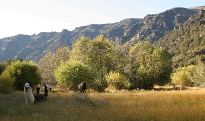
Llama Pack Trip: Cold Springs Loop
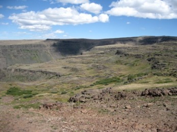
The loop hike to Cold Springs provides a very different experience than most people have when visiting Steens Mountain. While it does not enter one of the fantastic glacial gorges, it gives the hiker magnificent views down into one. By climbing the rise at the mouth of Little Blitzen gorge, one is delivered onto the high plateau where one can walk along the edge and peer down into the canyon below. The view is not for the faint of heart but serves those pining for eagles wings very well.
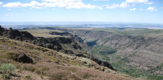
This route also provides gentle traverses of the upper and lower plateaus where expansive views emphasize the vastness of the landscape. In the image above, the Cold Springs route skirts along the edge of the far cliffs in the upper center of the view.
 Please note: the following description is presented for your convenience. We bear no responsibility for how you use the information. Conditions may have changed since the route was scouted, and it is strongly recommended that you inquire for up-to-date details as you plan your trip. Contact the Burns District BLM office. Please note: the following description is presented for your convenience. We bear no responsibility for how you use the information. Conditions may have changed since the route was scouted, and it is strongly recommended that you inquire for up-to-date details as you plan your trip. Contact the Burns District BLM office.
|
|
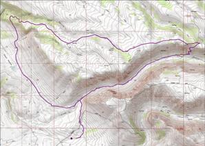
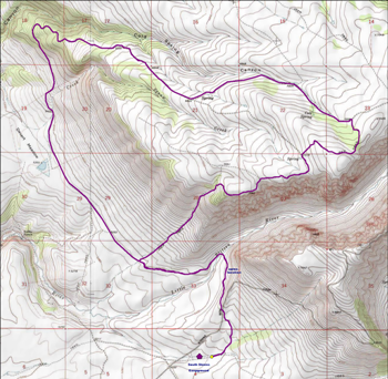 The route begins and ends at South Steens Campground. Using the Little Blitzen Trail, the route crosses Little Blitzen Creek before diverging by swinging northwest across the broad grassy flat of the lower plateau. Within about a mile, the route intersects an old jeep track that climbs directly up the slope to the upper plateau. Once on top the land is gentle and rolling with tremendous views. Dense brush makes following the old jeep trails a choice means of getting around. Choosing the track to Cold Spring will eventually provide a gentler decent to the lower plateau than the initial climb. The route then passes through Desert Meadows and back to South Steens Campground.
 Hazards on the route include crossing the Little Blitzen River (a stream-sized flow that can be challenging during periods of high run-off), rocky ground, the steep climb to the upper plateau and drops of thousands of feet along the upper edge of the gorge. Hazards on the route include crossing the Little Blitzen River (a stream-sized flow that can be challenging during periods of high run-off), rocky ground, the steep climb to the upper plateau and drops of thousands of feet along the upper edge of the gorge.
Highlights are centered around the incredible views and sense of expansiveness the terrain provides.
|
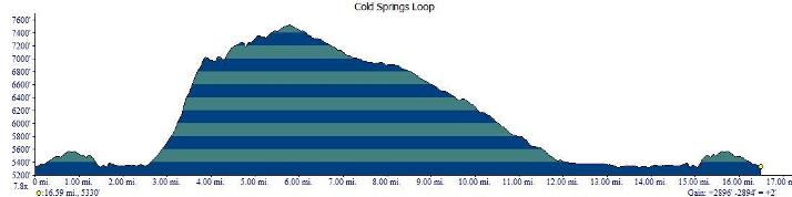
The sixteen and a half mile route shown in the profile above includes considerable climbing. Beginning at 5300 feet at South Steens Campground it takes you to a high point of 7500 feet overlooking Little Blitzen Gorge for a total climb of nearly 3000 feet. This is not a route for the faint of heart.
The initial climb rises about 1650 feet in one and a third miles at a 25% grade. The footbed is an old abandoned jeep track, with rocky and difficult footing. This climb is for the fit and adventurous only. To return to the lower level from the plateau above is much less difficult as it follows the Cold Springs 'road', a little used jeep track, over a six and a half mile continuous grade of 7%.
A single cross country section is required. It spans about three quarters of a mile between the mouth of Little Blitzen Gorge and the jeep track that connects with the Cold Springs 'road' in Desert Meadow. This section often has a fairly well defined animal trail. It is a straight forward walk across a gentle flat.
 There are alternatives to the steep ascent described above. One could do the loop in reverse, but that would mean descending the steep grade which could be even more difficult. Another option is to extend the route by hiking into Little Blitzen Gorge and climbing out via the trail to Nye cabin. There are alternatives to the steep ascent described above. One could do the loop in reverse, but that would mean descending the steep grade which could be even more difficult. Another option is to extend the route by hiking into Little Blitzen Gorge and climbing out via the trail to Nye cabin. 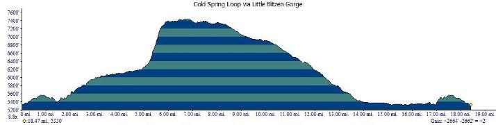 The trail scales the walls of the gorge (as shown in the photo at the top of this page) by climbing for about a mile with a 1200 foot elevation gain. The steepest portion ascends 900 feet in one half mile at a grade of 32%. Condition of this trail is not known at the present time. The trail scales the walls of the gorge (as shown in the photo at the top of this page) by climbing for about a mile with a 1200 foot elevation gain. The steepest portion ascends 900 feet in one half mile at a grade of 32%. Condition of this trail is not known at the present time.
 This route is about 18.5 miles long with a total elevation gain and loss of about 2700 feet. Redesigning the route in this way eliminates the walk along the upper edge of the gorge wall replacing it with the experience of being in the gorge itself. It also provides the opportunity to camp beside the Little Blitzen River under the cottonwoods in the valley of a magnificent U-shaped glacial gorge; a rare and distinctly western experience. This route is about 18.5 miles long with a total elevation gain and loss of about 2700 feet. Redesigning the route in this way eliminates the walk along the upper edge of the gorge wall replacing it with the experience of being in the gorge itself. It also provides the opportunity to camp beside the Little Blitzen River under the cottonwoods in the valley of a magnificent U-shaped glacial gorge; a rare and distinctly western experience.
|
|
Back to Top
Website update: 02FEB2022
© Burns Llama Trailblazers LLC herd@burnsllamatrailblazers.com
|
|