|
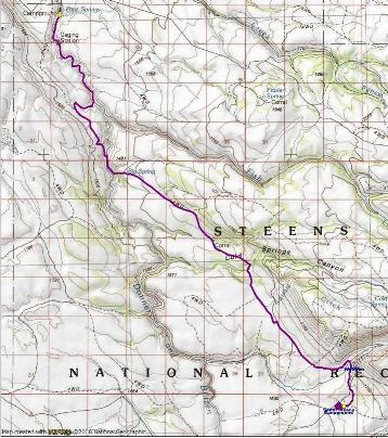
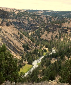
Steens Mountain, giant fault block formation that it is, slopes long and gently on its western side. Cutting through this nearly flat terrain, the Donner und Blitzen (Thunder and Lightening) River roars through its deep, rimrock walled canyon. At the north end lies Page Springs Campground just a few miles east of Frenchglen. about 17 'trail' miles to the south lies South Steens Campground. Much of the hike between follows the BLM's suggested Desert Trail route and provides a fascinating view of little visited country.
Please note: the following description is being presented for your convenience. We bear no responsibility for how you use it. Since conditions may have changed since the route was scouted it is strongly recommended that you inquire for up-to-date information as you plan your trip.
|
|
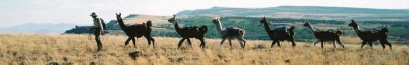
Llama Pack Trip: South Steens Campground to Page Spring Campground
The route between South Steens Campground and Page Springs follows old jeep tracks, animal trails and hiker user trails. The footing is rocky and at least one ford is required. As described here, multiple fords are necessary as one follows the river into Page Springs Campground. These can be avoided by staying on the jeep track that crosses the upland on the west side of the river. This is a much easier route but misses the pleasure of experiencing the walk along a wild desert river.
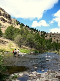 The Donner und Blitzen, unlike most desert streams is a perennial river. Its flow fluctuates seasonally but is most responsive to early summer snow-melt. During this period it can run high and wild and be impossible to cross. Since the Big Springs crossing is required in order to follow described route, trip planners should inquire about water levels before undertaking the trip. If one wishes to make the journey without crossing the river, the bridge on South Steens Road could be used. The Donner und Blitzen, unlike most desert streams is a perennial river. Its flow fluctuates seasonally but is most responsive to early summer snow-melt. During this period it can run high and wild and be impossible to cross. Since the Big Springs crossing is required in order to follow described route, trip planners should inquire about water levels before undertaking the trip. If one wishes to make the journey without crossing the river, the bridge on South Steens Road could be used.
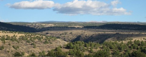
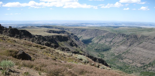
Be aware, this is an extremely rocky landscape. Steens Mountain was built from seemingly endless lava flows and you will be walking across or through them the entire way. This factor can make a short 17 mile hike take much longer than anticipated. On the uplands it can be hard to find a rock-free place large enough to set up a tent. This is also desert. Water should not be expected except at the river and springs shown on the topographic maps.
|
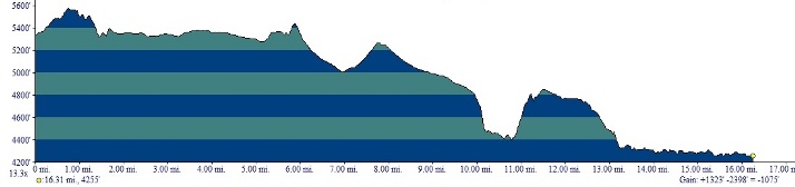  The route as described here is about 17 miles long. It involves a total elevation loss of nearly 2400 feet, which is offset by a gain of some 1300 feet as one climbs in and out of the Donner und Blitzen Gorge. Otherwise it is a relatively flat walk. Two cross-country sections require cross-country travel. One spans about three quarters of a mile between the mouth of Little Blitzen gorge and the jeep track that connects with the Cold Springs 'road' in Desert Meadow. This section often has a fairly well defined animal trail. With or without, it is a straight-forward walk across a gentle flat. The route as described here is about 17 miles long. It involves a total elevation loss of nearly 2400 feet, which is offset by a gain of some 1300 feet as one climbs in and out of the Donner und Blitzen Gorge. Otherwise it is a relatively flat walk. Two cross-country sections require cross-country travel. One spans about three quarters of a mile between the mouth of Little Blitzen gorge and the jeep track that connects with the Cold Springs 'road' in Desert Meadow. This section often has a fairly well defined animal trail. With or without, it is a straight-forward walk across a gentle flat.
More demanding is the drop to the river near the north end of the route. This stretch follows a steep, rocky draw with no defined trail for about three quarters of a mile at an 11% grade for a drop of over 400 feet. Many people may find it difficult. It is not recommended for inexperienced, out of shape or unschooled llamas or humans.
This section can easily be avoided by remaining on the jeep track as it crosses the slope above the river. Although it passes through country heavily grazed by cattle, it will lead you to the Steens Loop Road near the entrance to Page Springs Campground.
|
| |
THE DESERT TRAIL
The Desert Trail was originally envisioned by a group of desert enthusiasts, as a National Scenic Trail that would explore the arid country of the American West. It runs from Jacumba, California on the Mexican border to Snowy Top in the Selkirk Mountains on the Canadian border, a distance of some 2,223 miles. En route it traverses the Mojave Desert, Death Valley, the Black Rock Desert, the Pueblo Mountains, Steens Mountain, the Blue Mountains, the Columbia Plateau, and finally, the Selkirk Mountains. The trail crosses a plethora of fascinating and little known or visited landscapes including alpine meadows, lakes teeming with waterfowl, desert streams, falls, caves, chasms, gorges, sand dunes, and even volcanic craters.
 Much has been accomplished by volunteers to make on-the-ground existence of the trail a reality. Federal Agencies including the Bureau of Land Management, The US Forest Service, The National Park Service, and the U.S. Department of Fish and Wildlife have been actively assisting with identifying a route across lands they administer. In the vicinity of Steens Mountain, eight sections of the trail have been completed. They stretch continuously from High Rock Canyon in northern Nevada across the Pueblo Mountains and Steens Mountain to highway 78 southeast of Burns, Oregon. Much has been accomplished by volunteers to make on-the-ground existence of the trail a reality. Federal Agencies including the Bureau of Land Management, The US Forest Service, The National Park Service, and the U.S. Department of Fish and Wildlife have been actively assisting with identifying a route across lands they administer. In the vicinity of Steens Mountain, eight sections of the trail have been completed. They stretch continuously from High Rock Canyon in northern Nevada across the Pueblo Mountains and Steens Mountain to highway 78 southeast of Burns, Oregon.
The trail is actually a route. It sometimes uses jeep track, cattle paths, animal trails, or just strikes off cross country where it is often marked with cairns. No actual designated footpath exists. Choosing the precise route is left up to the individual traveler. Hiking the Desert Trail is a never-to-be-forgotten experience of solitude and exploration. Maps and information can be found at the Desert Trail Organization website.
|
Back to Top
Website update: 02FEB2022
© Burns Llama Trailblazers LLC herd@burnsllamatrailblazers.com
|
|