|
DATES AND TRIALS
BLT 2024 Spring Pack Trial
- Friday May 3rd through Sunday May 5th.
- Trials for Basic, Master, and Elite levels will be held.
- Advanced level trials will be considered depending on need.
- Trials will take place near Burns, Oregon
- Please contact us for details
BLT 2024 Summer and Fall Pack Trials
- Dates to be determined. Please let us know your needs.
- Basic, Advanced, Master, and Elite trials are possible.
- Trials will take place near Burns, Oregon
*******
- Llamas may participate individually or in strings.
- Please let us know two weeks ahead of the date if you are interested in participating.
- Llama-less handlers are always needed and are very welcome.
For more information contact Becky Cunningham at herd@burnsllamatrailblazers.com or (541) 589-0840
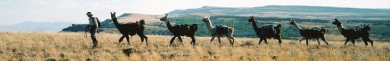
ABOUT PACK TRIALS WITH BURNS LLAMA TRAILBLAZERS
Every year Burns Llama Trailblazers hosts at least one PLTA Pack Trial event at locations alternating between ponderosa forest along Myrtle Creek on the Malheur National Forest and an area of sagebrush/juniper steppe in the canyons and rimrock we refer to as 'Becky's Backyard' on BLM land near Burns, Oregon. Locations are chosen based on snow pack, weather conditions, and hunting seasons. Recent changes in PLTA (Pack Llama Trail Association) requirements allow us greater leeway in choosing courses and locations. Details of typical courses are shown below. 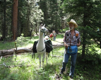
LOCATION & AMENITIES
Burns is located in southeast Oregon. The combined population of it and neighboring Hines is nearly 5000, making the twin cities the population center and county seat of vast Harney County. As such it has appropriate amenities including two large grocery stores, a BIG R farm store, a builder's supply, Les Scwab Tire Center, auto dealerships and numerous shops (and the best quilt shop for 200 miles). Most last minute needs can be supplied here.
ACCOMMODATIONS
Burns, Oregon is a way-station on the long drive between population centers. As such it has numerous motels and a Good Sam Campground. Forest camping is available at Joaquin Miller Campground, an equestrian site complete with corrals for your stock. It is located about 15 miles north of Burns and, although a beautiful site, gets very little use. A nice dispersed campsite (no amenities) is located half a mile south of the trailhead. It has room for multiple large trailers and vehicles. You will find links to area businesses at the Harney County Chamber of Commerce.
WEATHER
Weather in Harney County is highly variable. Expect snow any time of year. We typically have one day of snow or cold weather and one day of hot weather (80 degrees or higher) during the pack trials. Layering clothing and carrying plenty of it along with sunscreen and a hat with a wide brim, energy snacks and plenty of drinking water are highly recommended.
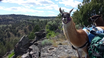
BECKY'S BACKYARD PACK TRIALS
ACCESS
"Becky's Backyard" is what we call a local area of mixed BLM and private ranch land. Located about three miles north of Burns, Oregon, it is accessed via Radar Lane (sometimes referred to as Radar Hill Road) a county road that begins as pavement on the Burns Paiute Reservation and turns to a well maintained gravel surface within about a half mile. No trailhead or facilities are available. Trial courses begin on private land. Adequate parking is available for stock trailers.
 THE SITE
This is where the physiographic Basin and Range province ends. Trial courses clamber through the last of the canyons and tables before the land rises to the pine covered Blue Mountains. Courses follow cross-country routes and animal trails over ancient lava beds and through rimrock cliffs. Sagebrush and juniper trees alternate with grassy expanses. Vistas spread out wide over the vast Harney Basin. Snowy Steens Mountain and Strawberry Mountain, each over seventy miles distant, punctuate the southern and northern horizon. After a moist winter, wildflower displays are spectacular. Courses begin at an elevation of about 4300 feet. Master and Elite courses climb to near 5000 feet.
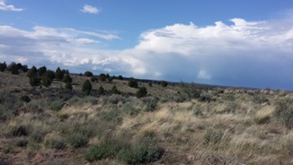
Pack Trial Courses at Becky's Backyard vary from year to year based on cattle grazing and water locations. All are designed to show off the fantastic hiking opportunities of Oregon's wild southeast corner. Maintained hiking trails are nearly nonexistent in this country. You don't need them anyway. It is easy to wander freely. The courses give you a taste for this as well as leading you along animal trails and well established cow paths. You can be sure you will not meet other hikers. Except for cows, and a maybe a rattlesnake if you are very lucky, you and your llamas will have the place to yourselves.
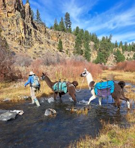
MYRTLE CREEK PACK TRIALS
ACCESS
The Myrtle Creek Trailhead is reached via a paved two lane forest service road. Parking at the trailhead accommodates pickups with trailers. To reach the trailhead, travel north from Burns on US Highway 395 approximately 16 miles to Forest Service road 31. Travel west and north on the 31 road to Forest Service spur road 3100-226. The trailhead is located at the end of the spur road. A Printable map of the trail is available at Myrtle Creek Trail, Malheur National Forest.
 THE SITE
Myrtle Creek Trail is located on the Malheur National Forest about 30 miles north of Burns. The pack trial courses are centered around scenic Myrtle Creek as it flows through grassy ponderosa pine forest in a deep canyon. The trials use Myrtle Creek Trail, well-defined elk trails, and old logging trails and roads. Elevation at the trailhead is 5400 feet.
While the Basic and Advanced trials stay at lower elevations along the creek, the Master and Elite climb to about 6000 feet. Despite what may seem like high elevations to some, this is not an alpine zone. All trials remain well within the ponderosa pine ecosystem.
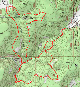
The map at left shows topograpy and routes used by the courses.
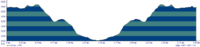
The Myrtle Creek Basic Course follows a maintained hiking trail along Myrtle Creek from the trail head to the creek crossing and back. Lunch is generally taken at the flowery meadow near the crossing. Elevation loss and gain is 400 feet. Elevation at the trailhead is 5388 feet while the creek crossing lies at 5054 feet. The trail drops to the creek crossing via two inclines of about 190 feet each with relatively gentle grades of nine to fourteen percent. The course length is three miles.
The Myrtle Creek Advanced Course also follows along Myrtle Creek to the crossing and back but it continues farther as well as climbing away from the creek via the West Myrtle Trail. The entire length is on maintained Forest Service hiking trail. The steepest climb is about 0.2 miles at a 17% grade. The highest elevation reached is 5420 feet. Total distance is five miles with a total elevation loss and gain of about 850 feet.
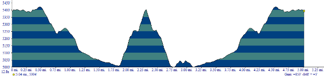
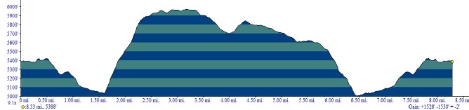
The Myrtle Creek Master Course climbs out of the canyon and well away from Myrtle Creek. It uses cross country routes, old logging roads and elk trails as well as the forest service hiking trail. The route includes a visit to scenic Crane Flat and an interesting juniper scabland. The highest elevation reached lies at 6000 feet while the lowest is at about 4990 feet. The longest single climb is about 900 feet across a third of a mile at a 16% grade. Total distance is about 8.25 miles while total elevation loss and gain is just over 1500 feet.
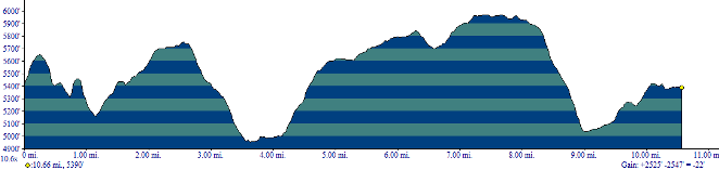
The Myrtle Creek Elite Course follows most of the Masters course, but when the Masters return to the trailhead via the Myrtle Creek trail, Elite candidates continue downstream along Myrtle Creek before crossing the creek and adding another hill climb. This final loop of the route is almost all either cross-country or on elk trails. The high elevation reached is the same as for the Master's at 6000 feet. The lowest elevation is about 4975 feet. The added long incline climbs 780 feet in about half a mile at a 16% grade. Total elevation loss and gain is just over 2500 feet while the total length of the course is about 10.5 miles
|